Applications
Below a list of my achievements in canopy photography.
2026 - Linking canopy structure to forest management
In a recent study led by Martina Montis & Anna Tozzi, we found that management in chestnut groves have different impact on canopy structure, as estimated from digital cover photography, which is a main driver of understory plant diversity.

The study is an important demonstration on how canopy photography can be used as operational tool to evaluate the impact of management practices on diversity.
The article is available at: M. Montis, A. Tozzi, L. Balducci, F. Napoleone, F. Chianucci, L. Middei, R. Duflot, P. Schall, S. Burrascano, 2026. The mosaic of management strategies drives the contribution of chestnut groves to plant diversity. Agriculture, Ecosystems & Environment, Volume 411, https://doi.org/10.1016/j.agee.2026.110551
2025 - CrowNet: 3-years of camera monitoring
In this study, recently accepted in Agricultural and Forest Meteorology, we presented results from a trail camera monitoring network (CrowNet), encompassing 20 forest stands in 3 forest areas and 3 years.
Using the cheap trail camera system, we collected more than 44,000 canopy images, from which daily canopy structure, continuous time series, and phenological transition stages, were inferred.
The dataset is available at: Chianucci, Francesco; Lenzi, Alice; Minari, Emma; Gonnelli, Marco (2025), “CrowNet: a trail-camera canopy monitoring system”, Mendeley Data, V1, doi: 10.17632/gkr667jvhx.1
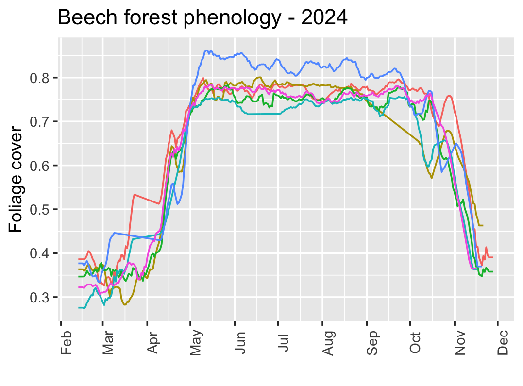
We illustrated the potential applications of the trail camera monitoring system by comparing derived trail camera canopy attributes against repeated multispectral and LiDAR UAV measurements. Results indicated the potential applications of trail cameras for complementing, integrating or validating multi-temporal remotely-sensed data, and for performing vegetation phenology analyses at tree to stand scale.
Chianucci F., Lenzi A., et al. CrowNet: A trail-camera monitoring system. Agricultural and Forest Meteorology (2025), doi: 10.1016/j.agrformet.2025.110596
2025 - Ecologically-relevant canopy photography
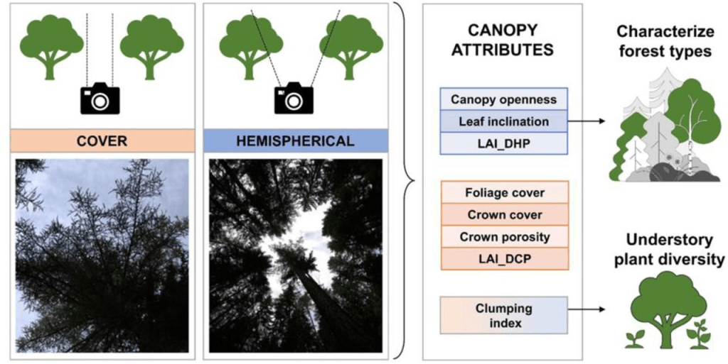
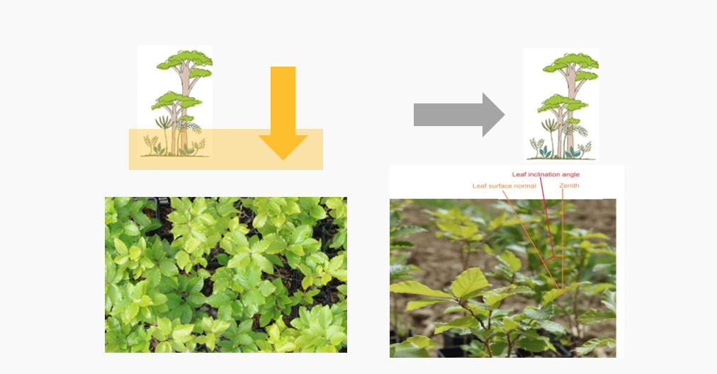
In this study led by Anouk von Meijenfekdt, we evaluated which canopy photography technique between fisheye (DHP) and cover (DCP) photography is suited for forest ecology applications. Our results indicated that DHP allows to discriminate between forest types, with openness and leaf inclination angles being the most relevant canopy attributes to capture ecological differences. In addition foliage clumping better explain variability in understory plant diversity, because it sustain heterogeneity of light regime at the forest floor. While DHP is more suited for forest ecology and biodiversity studies, particularly in sessile organism like plants, mosses and lichens, we hypothesized that repeated DCP can be used for assessing mobile organism with pronounced phenology like insects and birds.
von Meijenfeldt, A., Chianucci, F., Rigo, F., Ottenburghs, J., Hilpold, A. and Mina, M., 2025. Reliability of canopy photography for forest ecology and biodiversity studies. Ecological Indicators 172, https://doi.org/10.1016/j.ecolind.2025.113293
2024 - Linking canopy and diversity
Canopy attributes from digital photography has been typically used for forest monitoring (Fournier et Hall 2017) and understanding the influence of management on forest structure (Chianucci et al. 2016). Relatively few studies used these canopy attributes to understand diversity pattern, with the exception of understory plant diversity. Starting with a collaboration with Rigo et al. (2024), we explored the influence of canopy openness on bat and bird diversity. This study potentially allows extending the domain of canopy photography applications to multi-taxon forest diversity.
Rigo, F., Paniccia, C., Anderle, M., Chianucci, F., Obojes, N., Tappeiner, U., Hilpold, A. and Mina, M., 2024. Relating forest structural characteristics to bat and bird diversity in the Italian Alps. Forest Ecology and Management, 554, p.121673. doi: https://doi.org/10.1016/j.foreco.2023.121673
2023 - Review on cover
In this review paper, led by Linyuan Li, I collaborated on reviewing the many definitions related to vegetation cover fraction. Depending on the vegetation type, many different definitions (and acronyms) exist, which makes comparability challenging. The review standardized and harmonized the many definition of cover, provide a description of the many technologies and instruments available to quantify cover attributes, and describes their applications at various scales and vegetation types.
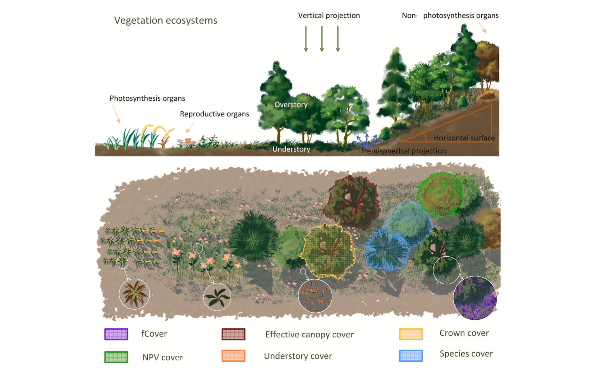
Li, L., Mu, X., Jiang, H., Chianucci, F., Hu, R., Song, W., Qi, J., Liu, S., Zhou, J., Chen, L. and Huang, H., 2023. Review of ground and aerial methods for vegetation cover fraction (fCover) and related quantities estimation: definitions, advances, challenges, and future perspectives. ISPRS Journal of Photogrammetry and Remote Sensing, 199, pp.133-156, doi: https://doi.org/10.1016/j.isprsjprs.2023.03.020
2022 - R packages for canopy image processing
In 2022 I developed some R packages to deal with canopy images. I started by creating coveR as I need a tool to process continuous cover images obtained from camera-traps. So the package was firstly designed for Digital Cover Photography (DCP) image processing, then I added functionalities for repeated photography applications, such as read EXIF and removing timestamp.

The second package was hemispheR, and it was designed for traditional hemispherical canopy images. This was motivated because no R packages allows to extract LAI from fisheye images. In addition, compared with other available free fisheye image analysis tools, I added more flexibility in analyzing both circular and fullframe fisheye imagery, while also implementing upward (tree) and downward (crop) canopy photographic approaches.


Another R package I have created was bRaw. The package implemented a method proposed by Macfarlane et al. (2014) which addressed the limitation that in-camera JPEG formats are sensitive to camera exposure. The package allows to convert RAW to 16-bit images, apply a linear contrast strech and export as 8-bit JPEG, yielding large camera exposure insensitive results.
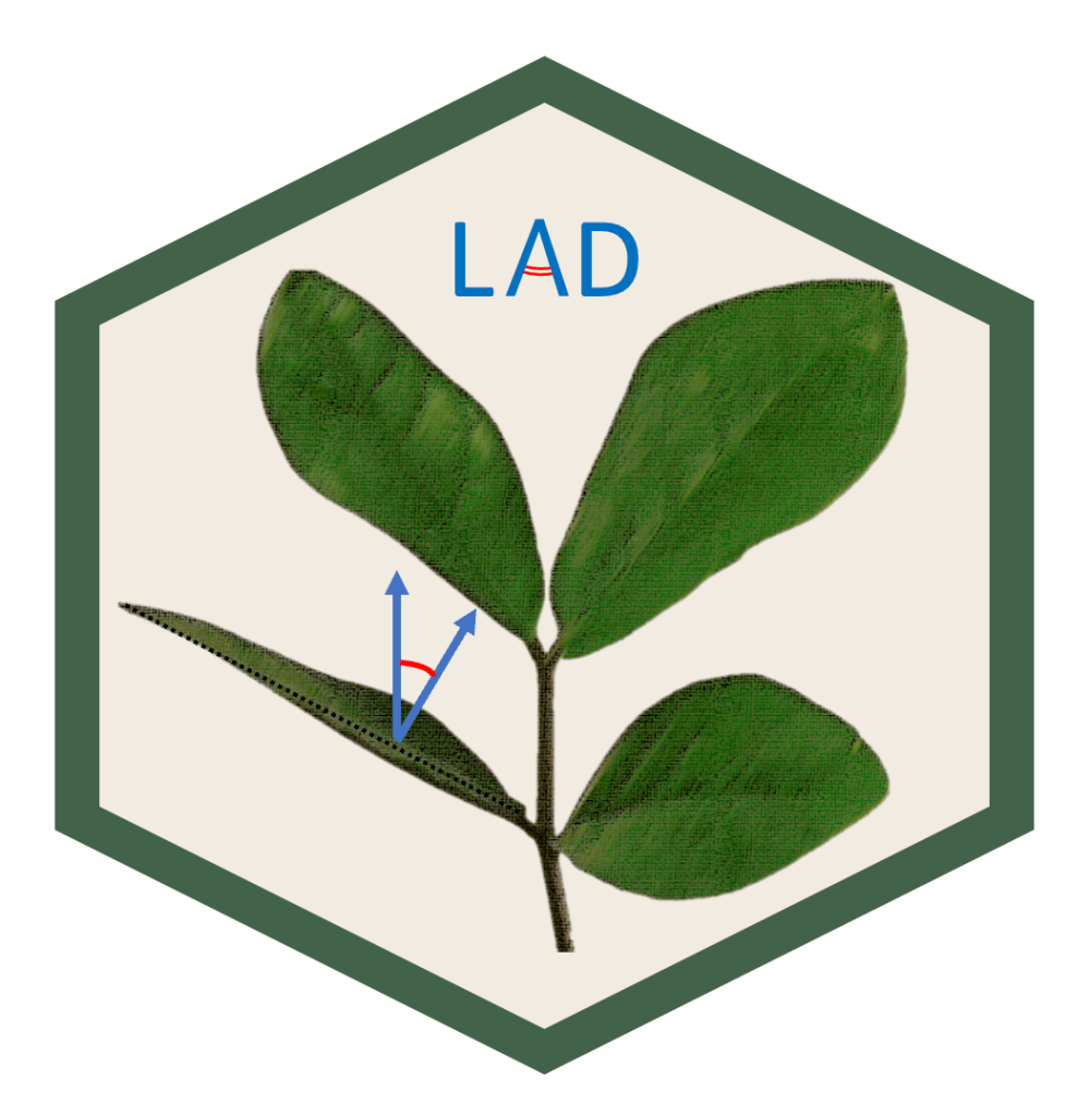
Finally, I have created the LAD package to fit the leaf angle distribution (LAD) and G-function from measured leaf inclination angles, which can be obtained from leveled photography.
![]()
In 2023 I have also created the LAIr package. It applies conversion formulas to estimate LAI from NDVI data, which can be collected from many multi-spectral or hyperspectral sensors. Therefore, the package can be used for large-scale mapping of LAI from raster imagery and field NDVI data.
Article references for the packages:
Chianucci, F., Ferrara, C. & Puletti, N. coveR: an R package for processing digital cover photography images to retrieve forest canopy attributes. Trees (2022). https://doi.org/10.1007/s00468-022-02338-5
Chianucci, F. and Macek, M., 2023. hemispheR: an R package for fisheye canopy image analysis. Agricultural and Forest Meteorology, 336, p.109470. https://doi.org/10.1016/j.agrformet.2023.109470
Chianucci, F. 2022. bRaw: an R package for digital raw canopy imagery. bioRxiv 2022.10.25.513518; doi: https://doi.org/10.1101/2022.10.25.513518
Chianucci, F., Cesaretti L. 2022. LAD: an R package to estimate leaf angle distribution from measured leaf inclination angles. bioRxiv 2022.10.28.513998; doi: https://doi.org/10.1101/2022.10.28.513998
Chianucci et al. 2023. LAIr: an R package to convert Leaf Area Index (LAI) from Normalized Difference Vegetation Index (NDVI). SoftwareX, doi: https://doi.org/10.1016/j.softx.2024.101776
R repositories on CRAN:
- CRAN:
- gitlab (dev-only):
treespat: https://gitlab.com/fchianucci/treespat (tree-spatial diversity indices)
2021 - Trail cameras for continuous canopy monitoring
Trail and wildlife cameras are cheap digital cameras designed for extended and unsupervised use outdoor. These cameras have been typically used for animal movement ecology. However, these cameras are potentially suited for continuous canopy monitoring, as they are rugged, have low-battery consumption, enable restricted view cover photography, and can be typically programmed for repeated image acquisition. Some camera models also feature data transmission protocols.
I used a very cheap ($ 60) wildlife camera oriented upward to acquire three daily images of a deciduous oak forest for one year using the in-camera’s time-lapse feature. Batteries have been replaced once during one year. Using an automated procedure, I obtained a screened daily-time series, from which phenological continuous functions have been fitted to extract key phenological stages. Results showed the strong potential of using trail camera for field continuous canopy and phenology monitoring, which can be used to calibrate and complement satellite phenology. Importantly, the standard, cheap and widespread trail camera technology holds strong potential to create a large scale phenological monitoring network of camera ‘traps’.
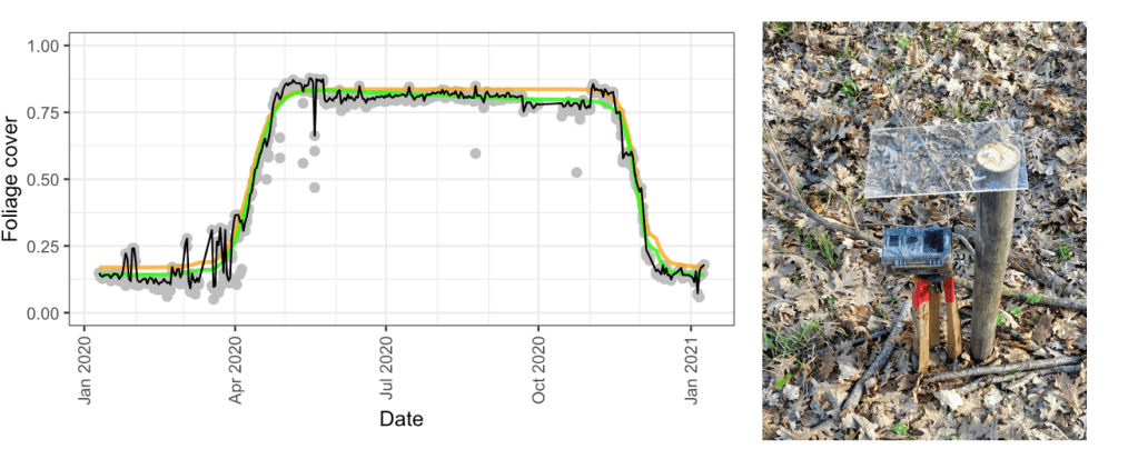
Chianucci, F., Bajocco, S., Ferrara, C. (2021). Continuous observations of forest canopy structure using low-cost digital camera traps. Agricultural and Forest Meteorology, 307, 108516. https://doi.org/10.1016/j.agrformet.2021.108516
Four years after the idea of using trail cameras for continuous monitoring, I compiled a three-years large dataset based on a network of trail-cameras (CrowNet)
2020 - A review on canopy photography in forestry
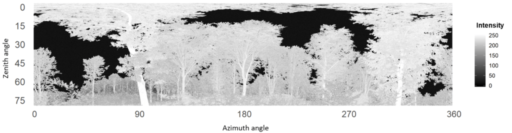
Since the pioneering works in the 1960s, film hemispherical photography has been extensively used in forest applications. Digital photography technology supported advances in canopy photography over the last decades. More recently, the development of restricted-view techniques like cover photography greatly expanded the range of applications and platforms implementing digital canopy photography. In this review I revised all the literature concerning canopy photography, from pioneering film photography up to last smartphone applications. Interestingly, image-based approach has been also tested in the same year to process intensity information from active phase-shift terrestrial laser scanning (TLS) sensors. This enabled a finest assessment of forest canopy structure at unprecedented detail than is possible with passive optical sensors.
The review can be found here: Chianucci, F. (2020). An overview of in situ digital canopy photography in forestry. Canadian Journal of Forest Research, 50(3), 227-242. https://doi.org/10.1139/cjfr-2019-0055
The study on image-based approaches in TLS is: Grotti, M., Calders, K., Origo, N., Puletti, N., Alivernini, A., Ferrara, C., Chianucci, F. (2020). An intensity, image-based method to estimate gap fraction, canopy openness and effective leaf area index from phase-shift terrestrial laser scanning. Agricultural and Forest Meteorology, 280, 107766. https://doi.org/10.1016/j.agrformet.2019.107766
2019 - A new clumping index in forest canopies
Optical methods derive canopy structure by theoretical formulas relating gap fraction to LAI. However, these formulas are based on the assumption of a random distribution of foliage, which rarely occurs in real canopies. For this reason, a clumping index was proposed since the 70s (Nilson, 1971) to account for the actual distribution of foliage in vegetation. So far, various methods have been proposed, but all these solutions are sub-optimal in denser canopies, such as temperate deciduous forests.
In this study I moved from mathematical and empirical considerations underlying a widely used logarithm averaging gap fraction method (LX), and proposed an improved version based on ordered-weighted averaging method (LXG), to account for both the gap fraction distribution and the magnitude of gap fraction, to improve the clumping index retrieval in denser canopies. I know, it seems pretty complicated, but in the study I also provide some codes and examples to explain it!
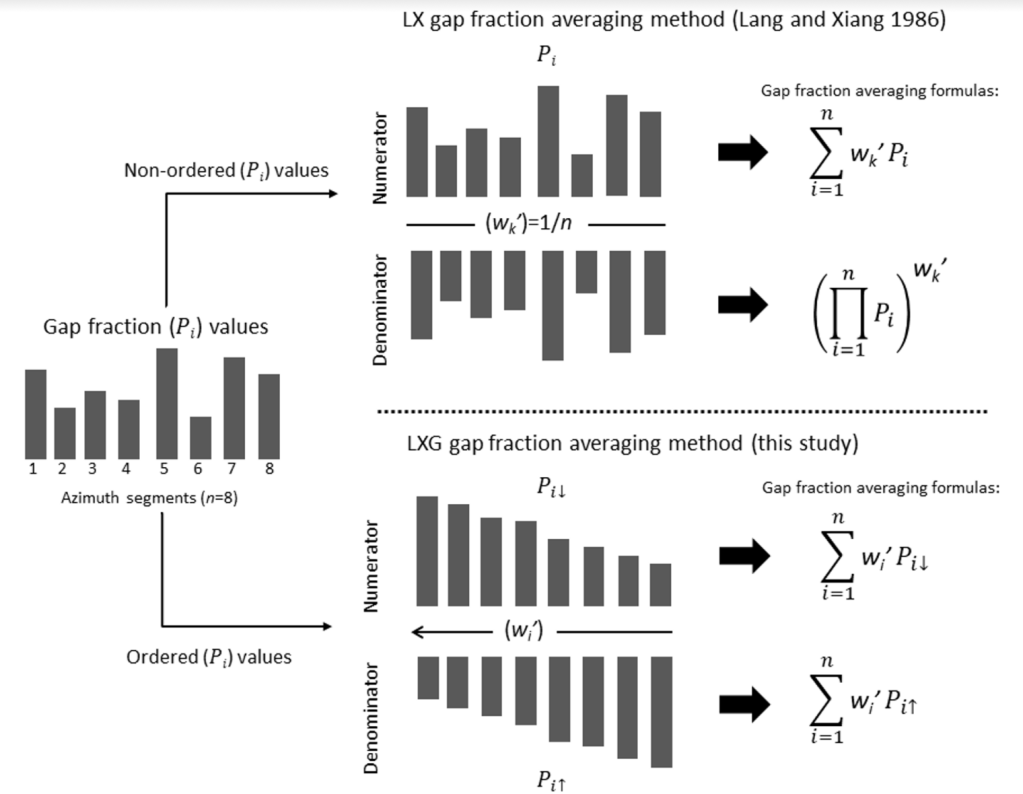
Chianucci, F., Zou, J., Leng, P., Zhuang, Y., Ferrara, C., 2019. A new method to estimate clumping index integrating gap fraction averaging with the analysis of gap size distribution. Canadian Journal of Forest Research, 49(5), 471-479.
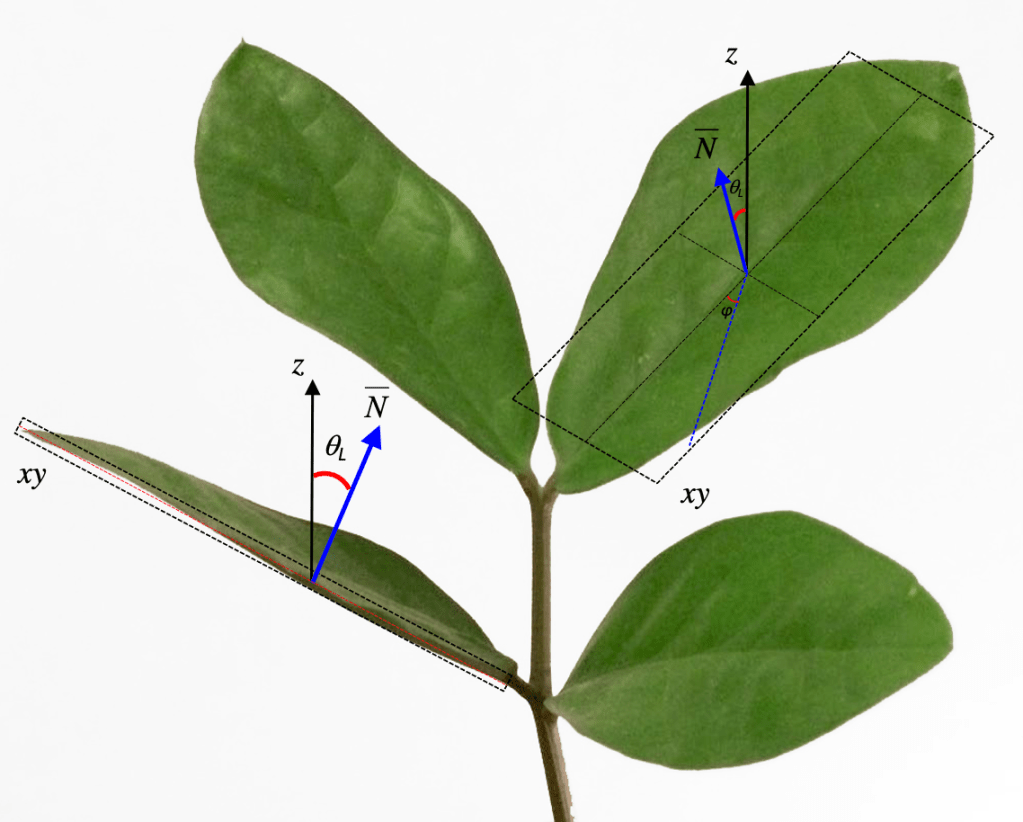
2018 - The largest dataset of tree leaf angles
Levelled photography (LP) was developed by Ryu et al. (2010) to measure leaf inclination angles and to characterise the leaf inclination angle distribution (LAD) of tree canopies. This parameter is critical for accurately modelling LAI from radiative transfer theory. However, direct measurements of leaf angles are hindered by the accessibility of crowns, particularly in tall trees. Using the LP technique, I compiled the largest existing global database of leaf angles for tree species. The dataset was the result of a very fruitful collaboration with Estonian colleagues Jan Pisek and Kairi Raabe, resulting in a list of 138 temperate and boreal tree species. The dataset also contributed to the development of TRY, the largest database of plant traits worldwide (Kattge et al. 2020).
Chianucci, F., Pisek, J., Raabe, K., Marchino, L., Ferrara, C., Corona, P., 2018. A dataset of leaf inclination angles for temperate and boreal broadleaf woody species. Annals of Forest Science, 75(2), pp.1-7. https://link.springer.com/article/10.1007/s13595-018-0730-x
2017 - eLTER H2020 Workshop on field LAI methods
In 2017 I served as trainer for a Workshop titled “Plant productivity and indexes as a proxy for basic ecosystem features” organized by eLTER (Long Term Ecosystem Research in Europe). Many LAI field methods and procedures were illustrated during the training. The workshop gave me the idea of writing a mini-manual for beginners and practitioners in canopy photography, which can be downloaded here. Some years after, the mini-manual helped me to create a comprehensive review on forest canopy photography.
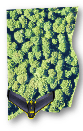
2016 - Canopy photography & UAVs
Unmanned aerial vehicles (UAVs) are platforms that have been increasingly used in the last few years in forestry, due to the combined advantage of higher spatial resolution, more flexible and quicker revisit time, and larger spatial coverage than is possible with traditional methods. In this study, I tested the use of true colour images acquired with a small fixed-wing UAV in dense beech canopies to retrieve LAI at plot-scale. Results were validated against field canopy photographs. Results are particularly relevant for forest monitoring, as UAV can potentially allow calibrating metrics from coarser scale remotely-sensed products, reducing field calibration efforts.
Chianucci, F., Disperati, L., Guzzi, D., Bianchini, D., Nardino, V., Lastri, C., Rindinella A., Corona, P. (2016). Estimation of canopy attributes in beech forests using true colour digital images from a small fixed-wing UAV. International journal of applied earth observation and geoinformation, 47, 60-68. https://doi.org/10.1016/j.jag.2015.12.005
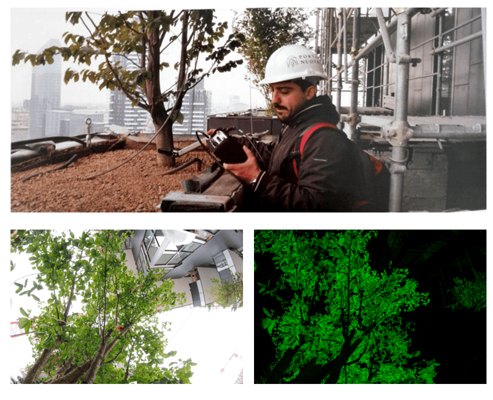
2015 - Estimating LAI in isolated and urban trees
LAI influences many ecophysiological processes which are also relevant in urban planning. For instance, urban tree canopies have a significant role in mitigating heat island effects, removing air pollutants and cooling buildings. However, traditional canopy photographic approaches are mostly suited for plot-level applications, which makes the estimation of single tree crown and canopy attributes challenging. This is particularly true for urban trees, where the proximity to urban infrastructure hinders the retrieval of gap fraction. During a field session in urban trees at Bosco Verticale skyscraper with the IUAV University of Venice, I get the idea of adapting a canopy photographic approach to estimate tree leaf area in isolated and urban trees. I compared both traditional single-channel thresholding with a visible vegetation index (GLA) in isolated trees sampled in open sky and under a building roof. Results were validated against the high quality quantum sensor (Plant Canopy Analyzer LAI-2000). The outcome shows strong potential for urban forest and urban greening applications.
Chianucci, F., Puletti, N., Giacomello, E., Cutini, A., Corona, P. (2015). Estimation of leaf area index in isolated trees with digital photography and its application to urban forestry. Urban Forestry & Urban Greening, 14(2), 377-382. https://doi.org/10.1016/j.ufug.2015.04.001
2014 - Estimating understory LAI
Understory hosts the vegetation growing at the forest floor. It is a key component of the ecosystem and drives forest regeneration and ecosystem dynamics. However, the estimate of understory canopy is complicated by the complexity of ground vegetation, soil, bare rock and litter, which create a spectrally-complex background against which ‘extract’ green vegetation information. Here I combined two innovative technologies, namely nadir understory photography developed by Macfarlane and Ogden (2012) and levelled photography formerly developed by Ryu et al. (2010) to estimate understory LAI from digital canopy images.
Chianucci, F., Cutini, A., Corona, P., Puletti, N. (2014). Estimation of leaf area index in understory deciduous trees using digital photography. Agricultural and Forest Meteorology, 198: 259-264. https://doi.org/10.1016/j.agrformet.2014.09.001
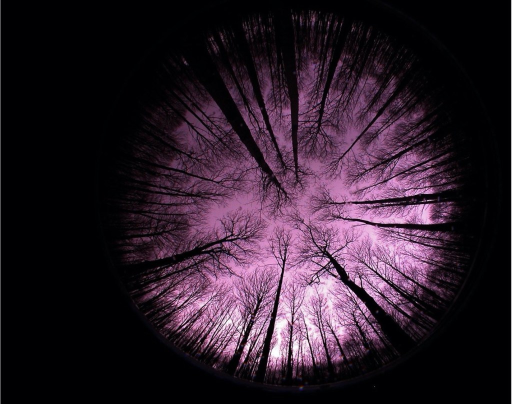
2013 - Digital hemispherical vs cover photography
Hemispherical (or fisheye) photography has been used for about half-a-century in forestry. A reputed advantage of this technique is that it allows to sample the largest footprint of a canopy on a single point. In addition, integrating gap fraction measurements at the full hemisphere allows to infer LAI from gap fraction without the need to measure - or know - the actual orientation of leaves in crowns. However, hemispherical photography also possesses some limitations, given the perceived sensitivity of results to sky conditions, camera exposure and gamma correction.
As alternative to hemispherical photography, I tested the cover photographic method by Craig Macfarlane & colleagues (Macfarlane et al. 2007), originally conceived for sparse Eucalyptus canopies. Compared to fisheye photography, cover photography is very simple, as it use a camera with a ‘normal’ (50 mm equivalent), often fixed lens, which makes the images less sensitive to camera exposure and sky conditions. The disadvantage of the method, is that it rather estimates canopy cover, as LAI requires independent knowledge of leaf orientation in narrow view sensors.
I really like cover photography! In a comparison in medium-dense temperate forests I showed its reliability to estimate canopy structure. Importantly, the restricted view format and use of a fixed lens hold great potential to extend this technique potentially to any kind of camera devices… keep reading!
Chianucci F., Cutini A. (2013) Estimation of canopy properties in deciduous forests with digital hemispherical and cover photography. Agricultural and Forest Meteorology. 168:130-139. https://doi.org/10.1016/j.agrformet.2012.09.002
2012 - Fisheye photography applications in forestry
The first fisheye lens was designed in 1924 by Robin Hill, to study cloud formation (Hill, 1924). In the 1960s, hemispherical photography was adopted by forest ecologists to study light environment since the pioneering works by Evans and Coombe (1959) and Margaret Anderson (1964). Since then, hemispherical photography has been widely used in forestry to estimate light regime and LAI. In my first study I reviewed the pros and cons on hemispherical photography, with a focus on the advances of digital cameras compared with the former film-based ones.
The article is freely available at: Chianucci F., Cutini A. (2012). Digital hemispherical photography for estimating forest canopy properties: current controversies and opportunities. iForest 5: 290-295. https://doi.org/10.3832/ifor0775-005.