Light Detection And Ranging (LiDAR), is an active technology which uses information from optically-directed laser beams to precisely obtain 3D information of target objects.
This technology have recently experienced a relevant upsurge of interest in forest ecology, largely supported by the recent advancements in terrestrial laser scanning (TLS) technology, which provide unprecedented 3D field information on trees and forests (Malhi et al. 2018).
While the basic premise for collecting 3D point cloud is similar across TLS instruments, distinct ranging methods have emerged: time-of-flight (TOF) and phase-shift (P-S) sensors. They differ primarily by a balance of cost and signal-to-noise ratio (SNR). Time-of-flight scanners emit laser pulse and measure the amount of time of return singles from intercepted targets. Phase-shift scanners emit a continuous signal, modulating frequency and amplitude to produce a unique outgoing signal.
Phase-shift sensors have many advantages as they are quicker, cheaper, lighter-weighted, and have lower beam divergence compared to TOF sensors, which yielded high-resolution data. However, P-S scanners are limited by their lower SNR, lower range, and increased ranging artifacts, particularly in complex canopies (Newnham et al., 2012), which generally reduced their deployment compared to TOF scanners.
As the main limitations of phase-shift scanner affected the 3D-point cloud, a new method was recently developed in a study led by Mirko Grotti and colleagues (Grotti et al. 2020) which is based only on laser return intensity (LRI). LRI is a raw measure of the backscatter of the signal recorded by the sensor, and thus it can be considered an unclassified version of the point cloud, as it captures the scene ‘viewed’ by the sensors, including point and non-point (gap data).
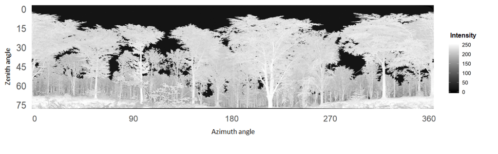
Intensity-images were derived from a phase-shift FARO Focus 3D x130 laser scanner and then processed using a procedure comparable to digital hemispherical photography:
- create a binary image of gap and canopy pixels by histogram analysis
- divide image in zenith (y) and azimuth (x) bins
- apply theoretical equation relating LAI to angular gap fraction
I compiled a MATLAB routine to process these intensity images, which is available here.
The new image-based methodology has many advantages:
- The intensity-based method is insensitive to range, as the image classification focused on gap, which by definition has nearly-zero intensity values;
- The intensity-based approach removes all the issues of point-cloud filtering in P-S scan data;
- Use intensity-only information allows accessing TLS data at its highest resolution (which is more than one order of magnitude higher compared to passive optical or TOF scan data)
In addition, the finest resolution achievable by TLS to sample the canopy and the theoretical background comparable to passive optical methods make the intensity-image approach an ideal benchmarking tool for validating indirect optical instruments and methods, avoiding the need of destructive, more time-consuming direct measurements.